এ জেলার পশ্চিম ও পশ্চিম-দক্ষিনাঞ্চলের স্থলভাগ ও জনবসতি প্রাচীনত্বের দাবিদার। জেলার প্রাচীন ভূভাগের অধিকাংশ এলাকা এক সময়ে গভীর জঙ্গলে আকীর্ণ ছিলো। এ সব জঙ্গলে বাঘ, ভালুক, মহিষ, শূকর ও অন্যান্য বনপশুর আস্তানা ছিলো। বাঘের ভয়ে এমনকি দিনের বেলাতেও এ সব জঙ্গলের ভিতর দিয়ে কেউ চলাচল করতে সাহস পেত না।২
কথিত আছে, ১৭৯২ সালে এমনকি ১৮৭৫ সালেও বাঘ শিকারের জন্য মাদারীপুরে পুরষ্কার দেয়া হয়েছিলো। ‘From the old records it is clear that the east of the district contained extensive stretches of jungle, which were the habitant of tigers and buffaloes. In 1792, rewards were paid for killing the Tigers in Madaripur, and even as late 1875, wild buffalos were common in the cold season.৩
১৮৮৩ সালের নভেম্বর মাসে সুবিখ্যাত পার্শী সিভিলিয়ান কে.জে বাদশা মাদারীপুর মহকুমার প্রশাসক নিযুক্ত হন। তাঁর সময়ে মাদারীপুরের অন্তর্গত স্থান সমূহের জঙ্গল পরিষ্কৃত হয়।৪
মাদারীপুর জলাভূমি হিসেবে চিহ্নিত হলেও এর নদীত্রয়ীর কূলভূক ক্ষুরধারা বারবার গ্রাস করে নিয়েছে বিপুল তীরাঞ্চল। মাদারীপুর মহকুমা শহরই বড়মাপে নদীভাঙন কবলিত হয়েছে অন্তত তিনবার। প্রথম দফা ভাঙনের পর মহকুমা সদর দপ্তর আড়িয়াল খাঁ নদীর একপার থেকে স্থানান্তরিত হয় অন্যপারে। ‘Headquarters of the Madaripur Subdivision situated at the Junction of the Arial Khan and Kumar rivers. The town stretches along the southern band of the former rivers, which is opt to cause erosion, and along the eastern bank of the latter river.’৫ বর্তমান পৌরসভা ও লেকের পাড়ের (লেক পার্ক) পুরানো কোর্ট ভবন গত শতাব্দীর পঞ্চাশ দশকের প্রথমপাদে দ্বিতীয়বারের নির্মিত স্থাপনা।
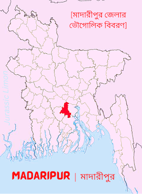
মাদারীপুর জেলা ২৩°০০′ উত্তর অক্ষাংশ থেকে ২০°৩০′ উত্তর অক্ষাংশ এবং ৮৯°৫৬′ পূর্ব দ্রাঘিমাংশ থেকে ৯০°২১′ পূর্ব দ্রাঘিমাংশের মধ্যে অবস্থিত। মাদারীপুরের আয়তন ১,১৪৪.৯৬ বর্গ কিলোমিটার। মাদারীপুর জেলার উত্তরে ফরিদপুর ও মুন্সিগঞ্জ জেলা, দক্ষিণে বরিশাল ও গোপালগঞ্জ জেলা, পূর্বে শরীয়তপুর জেলা এবং পশ্চিমে ফরিদপুর ও গোপালগঞ্জ জেলা।৬
তথ্যসূত্র : “মুক্তিযুদ্ধে মাদারীপুর”, লেখক—বেনজীর আহম্মদ টিপু, সার্বিক সাহিত্য প্রকাশনী, প্রথম প্রকাশ—আগস্ট ২০১৪, পৃষ্ঠা—(৩৩-৩৪)


2 Comments
Good Information.
ReplyDeleteThank you.
Delete•Do Not Share Any Link.
Thank You•